After almost 2 months travelling at
altitude between 3,000 - 5,000 meters (10,000-16,000 feet) we came back to sea-level for
our visit to Nazca and the ride south along the Pacific coast. We last saw the
ocean in southern Chile, back in February. The sandles haven't been out of the
panniers in months, and the color pertruding out from below our shorts is a ghastly
white!
Wednesday, July 10th: The day after our flight over the Nazca Lines (see
previous chapter), we decided to hang out in the garden of our hotel. Jesse, who we
met on our Machu Picchu trek, showed up with his friend Errol. Jesse was looking a
bit pink -- we later found out one of the other passengers in his 4-person Cesna got
air-sick, which triggered Jesse into losing his breakfast too. We got a group
together and in the early evening settled down for a few Happy Hour drinks.
Everyone was feeling quite pleasant, and I asked for volunteers to to cut my
hair. Errol jumped at the chance, and I got myself into a plastic chair before he
finished his 4th large beer -- Lucky thing I like a buzz cut!
Thursday, July 11th: A final farewell Kfir as he heads north and we head
south towards Arequipa. We spent the last 6 weeks travelling on and off with Kfir, and
will miss him. He's heading back to the states to his business selling nail kits
(clippers and files in leather pouch) from a cart in a Mall for Christmas -- don't laugh,
it's how he paid for 8 months travelling in South America. Not sure who is more
emotional at our departure, Kfir or Cuy, the guard dog that watches our bikes and can't
get enough human attention!
Guess what?!?! I finally got one...a confluence on the GPS....and I
practically fell onto it. A confluence (in this case) is where the interger degrees
of a Longitude and a Latitude intersect -- you know, those rings on a globe or lines on a
large map. Someone directed me to a website last year www.confluence.org that was trying to document all
the confluence's around the world. This may sound pretty simple, but it really isn't
-- to give you an idea: The distance between N43ş and N44ş (horizontal rings) is
roughly 69miles/111kms; while the distance between the vertical lines can vary, depending
on how close you are to the equator or either of the poles. For example, at N43°,
the distance between W75° and W76° in central New York State is roughly 51miles/83kms;
while down in the cocaine fields of Colombia, at N01°, the distance between the same
W75° and W76° is 69miles/111kms! So, you have to travel quite some distance to get
from one confluence to the next, and these are specific spots about the size of your
hand. If you are having trouble following this, trying looking at a globe
Being that I like to play with my GPS, looking for confluence's gives me something to
aim for when the road gets too straight/boring. Erin, on the other-hand, doesn't
share my enthusiasm on this subject (imagine that!). I have come close (within a few
miles) a few times, but not the type to trek 3-4 miles over wooded mountains, getting to a
confluence has not been easy. I had given up hope after the Salar de Uyuni in
Bolivia, a salt lake which stretches more than 125kms across and 100 top to bottom.
There were 2 confluence's within the Salar, with no obstacles to hinder my reaching
them. Unfortunately, we were with a tour, and I couldn't deviate 35kms north out of
the way.
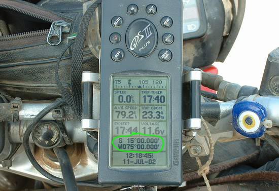
So anyway, we were about 23kms south of Nazca and I was checking the time on the main
info screen on the GPS, and noticed we were at S14.58.778 W74.59.110 --- something clicked
and I immediately stopped. I created a new waypoint with the coordinates for the
confluence S15.00 W75.00, and found we were only 1.18kms away! The area around was desert,
with parts of deep sand, but I was too close to not go for it. I hit the "go
to" button, and followed the arrow. Erin said she'd follow along the road, and
wait while I ventured off into the deep sand.
Well, would you believe this confluence is not way off the beaten track, but on the
(paved) shoulder of the north-bound lane on the main highway!!!! It was so easy, and
I wasn't even looking for it. I didn't know if anyone else had already registered
this confluence, but I really didn't care -- I way psyched! (When I went to
register, I discovered a nun was planning to visit this confluence later this month, and
thought it would be sacrilegious to register it before her. Oh well, I was still
happy)
After a few photos, we continued down the barren coast, as desert murky sands meld with
cleaner beach sand and left a light film on the highway. The coastline would be quite
extraordinary if not for the wind and haze that draped over us for the entire day.
Peruvians and Bolivians flock to the beaches for the summer months of January through
March, when the air is clear, there is no wind, and the beaches are at their finest.
We arrived in the beach resort town of Camana, after some 400kms. Most of the
houses on the beach look pretty crummy, and we later learn a Tsunami wiped them out the
previous year. We hunkered down at the Sun Valley resort, which has nice new cabanas near
the beach, and a sand dune for sand boarding out back. We’re the only guests, as it
is the off-season, so we have a wonderful fish dinner with the owners.
Friday, July 12th: A lazy and late start gets us to Arequipa late in the
afternoon. After finding our way to the Plaza de Armas (center of every city), a friendly
motorcycle policeman escorts us to several of the hostals on our list, eventually ending
up at a very quaint place, Tambo Viejo. After dinner, we found an internet café and it
takes us almost 2 hours to upload our previous chapters of Peru (it was that slow!)
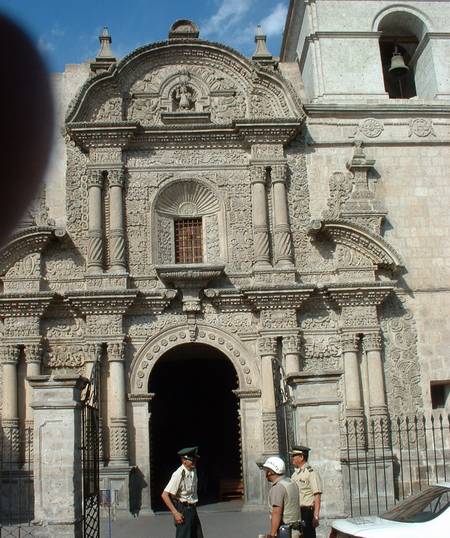
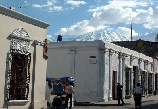
Saturday, July 13th: Arequipa is one of Erin's favorite cities we've visited
in South America. Big enough to have wonderful culture, yet small enough to retain a
sense of quaintness. Many of the important buildings are made from a white volcanic
stone, only found near the city. We meandered around the city, visiting markets and
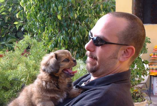
enjoying the many colonial style buildings and intricate facade. Arriving back to
the hostal exhausted, some of the animals decided we still had a bit of energy and wanted
to play.
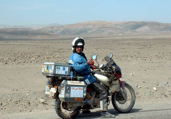
 Confluence on the road to
Arequipa
Confluence on the road to
Arequipa