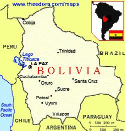
Tuesday, June 18th: Beautiful, clear sky day over
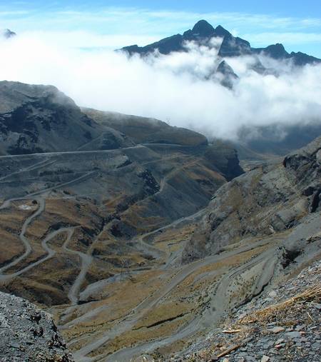
La Paz. We left about noon towards the town of Coroico, some 90kms away. The
second half the route would take us down the dirt/mud one-lane mountain path,
affectionately know at "the World’s Most Dangerous Road". The first hour we
climbed the mountain range to over 4,700 meters. At the pass there is a big stature of
Jesus looking down into the steep valley below. It was cold but we decided to ride up to
the statue anyway to take pictures of the beautiful snow topped mountains and breathtaking
view. When we descended into the valley below we were quickly enveloped in fog. I started
to notice a change in the flora as it transitioned from dry, high-altitude tundra to lush
green tropical rainforest. At about the half way point there was an agriculture/drug
checkpoint and lots of food stalls on the side of the road. We stopped here for a lunch of
delicious and very unhealthy fried egg, chorizo sausage and fried onion sandwiches. The
boys were nervous standing so close to the police checkpoint with dynamite sticks packed
on their bikes, so we move on fairly quickly.
We left the pavement and encountered the fork in the road that leads down to Coroico
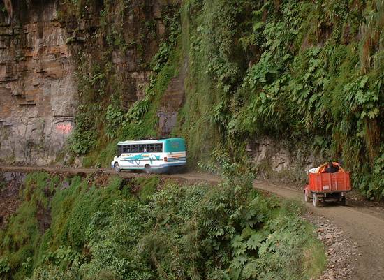
and the sign that says we now have to switch to left-side drive down the mountain. This is
so that the truck drivers heading downward can look out their side of the truck and gauge
their distance/closeness to the edge of the cliffs. Going down the mountain we are
on the cliff-side. Scary doesn’t even begin to describe the feeling in our stomachs
and the tightening of our muscles as we glanced down at the sheer drop. The road is
supposed to be one-way to Coroico in the morning and one-way the other way to La Paz in
the afternoon. Well, no one pays any attention to this. So you are constantly pulling off
to the side (cliff-side!) to let the big trucks and busses pass -- uphill traffic seemed
to have the "right-of-way". The trucks are filled with produce, various consumer
goods and loads of people on top hitching rides.
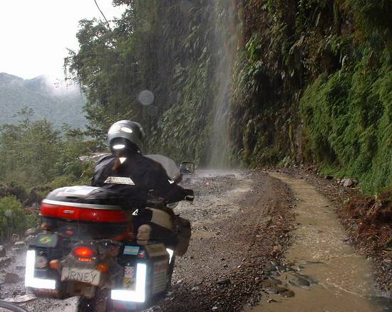
Because of the fog and mist the dirt road is slick with lots of rocks imbedded in it
which make the tires bounce from side to side. Then there’s the occasional waterfall
cascading on the road, beautiful to look at and fun to ride under! I felt sorry for
the poor people in the open truck beds. It took us about 2 hours to cover less than 20
kilometers due to all the stops for passing traffic and picture taking. We finally reached
to bottom of the valley (1,200 meters) and could see Coroico (1,700 meters) perched on the
side of the mountain above us. The temperature had risen dramatically and it was more
humid. Us in our thermal underwear were all sweating and struggling to strip off layers of
clothing. I noticed the bird life was more abundant and diverse, and spotted beautiful big
blue monarch butterflies in the bush on the side of the road.
After a little river crossing at a bend in the river we encountered an even bigger
obstacle---an honest-to-goodness landslide! There had obviously been a very recent, very
large slide on the side of the mountain, as evidenced by a bare earthen gash in the side
of the normally lush green mountainside. The road had been somewhat cleared but big rocks
(they size of basketballs) were still cascading down onto and over the road at regular
intervals. Well, we didn’t come all this way to turn right around! Fearless Kfir
decided to brave that section first, dodging the big rocks in the road while keeping one
eye uphill for the next slide. He helped to guide us across one by one giving us hand
signals about when it was safe to go and when to hurry the hell up before we were knocked
in the head by a boulder!
Thinking we had seen the worst of the road that day, we were wrong. There was another
fork in the road and we asked a passerby which one we should take to Coroico. He said take
the right one going uphill. Despite a sign saying the road was closed for construction, we
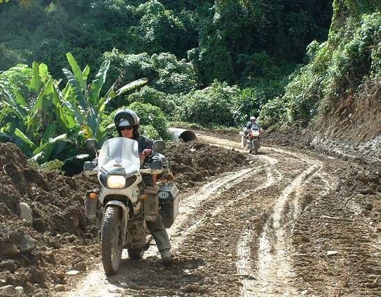
took it anyway. The road, although rough was not too bad, until we encountered our first
stretch of deep mud. After about 4 or 5 of these muddy stretches we saw that the road was
completely blocked with tractors and front-end loaders moving around large sections of
dirt. The workers told us if we waited 20 minutes they would be done for the day and clear
a path for us. Sure enough they were done quickly and we slipped and slided our way
through their section and up finally to the entrance of the village. Thank goodness the
fog had lifted and the place was dry because the roads in the village are all cobblestoned
and very steep! Muddied but relieved, we found the central plaza (which every town has)
easily and were immediately greeted by friendly touts trying to sell their accommodation.
Lucky for us this is a bit of a (rustic) resort place with lots of posh accommodation, and
it was off-season! We finally decided on a great place on a hill above town, with
drop-dead views of the whole valley, pool, sauna, garden, restaurant, big-screen TV with
videos, game room, etc. Decided immediately to stay the next day just to relax. We
got a huge room with private bath for just under US$10!
Wednesday, June 19th: Slept in late because it was cloudy and foggy outside.
It had rained during the night and the electricity was out. Met Liam and Kfir for
breakfast (a very good buffet!). By 11am they both decided not to venture back on the Dead
Road to La Paz that day, due to the steep muddy roads and the slick cobblestone streets to
get out of town. The boys played backgammon and pool the rest of the morning while I
recorded Liam’s CD’s onto my new mini-disc player. In the afternoon we walked
into town to have a look around. Found a nice little restaurant, which made its own fresh,
delicious pasta. The table was situated so that we could see the street scene out the
front door. Chris put the camera on the table and snapped pictures as interesting people,
cars, etc. wandered by. Later that evening we had another big buffet dinner and watched a
video after dinner with a bunch of Aussies, some Irish, and a few Germans.
Thursday, June 20th: I heard rain all night, which kept me up worrying about
the road conditions. We wanted to leave that day in order to get to another special place,
Tiwanaku near the Peru border. When we woke that morning the conditions were the same as
the day before, cloudy and wet. But, as we finished our breakfast we could see the sky
start to clear. We packed our bikes and by 11am were ready to leave. Kfir and Liam left
first and braved the slippery road down to town. Chris and I pulled up the rear and we
could see their tracks in the mud, sometimes sliding sideways. We reached the cobblestone
streets of Coroico and tried to glide our way down. I was petrified as I could feel my
back tire slipping side to side on the stones. We finally made it to the town plaza where
we met the other two. I was sweating profusely from the effort.
There were two roads out of town connecting with the Dead Road, one was the short way
(the 7km way we came up) and under construction. The other was the long way (twice as
long) and, we’d been told, has been chewed up since the construction on the other one
had begun. We opted for the short way down as we had a good idea what it would be like.
Sure enough, it was all muddy tracks for the first half of it. I had my feet down most of
the way (something I know I shouldn’t do) because mud is my worst fear when riding
the bike. It’s like riding on ice with little hope of traction. At one point we were
stuck behind the tractors and I slid out on some loose dirt and rocks and dropped the bike
trying to stop. Behind us were about 3 minivans full of tourists who cheered this. One
sympathetic soul jumped out of a minivan and helped me pick up the bike. He must be a
rider himself!
Sufficiently humiliated I got underway again. Luckily, by the halfway point the road
began to dry and we could finally ride the road more confidently. At the bottom there was
a long row of food stalls catering to the tourists and truck drivers. We stopped here for
a much needed break and refreshments (and let the tourist vans pass.)
Thinking the worst was behind us we pushed on our way back up the Dead Road. The
section of landslide we hit coming in seemed quiet when we passed by again. The road up
was not so difficult, partly because this time we were riding on the mountainside and
partly because it seemed like we had more control going up-hill. The roads were still
slick however and we had to take care not to lean the bikes over too much in the turns.
There were patches of opaque mist that concealed the road ahead of us, but thankfully we
got through those sections without too many problems! The traffic coming downhill
was very courteous and pulled over constantly to let us pass. We reached a semi-circular
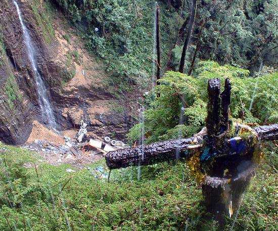
section of the road that had cascading waterfalls pouring down onto it. At this point all
the traffic was stopped on both sides. We found out from some of the locals standing on
the road that 2 days before we rode down this road a large commercial truck had managed to
miss a gear change in this section and slipped backwards off the side of the mountain. We
heard two stories, one said no one died and the other said that 4 people died (the driver
jumped out just in time). I tend to believe that 4 people died because every single truck
we saw had a full cab and was carrying a load of local hitchhikers on their way to La Paz.
It was very sad indeed. That’s why the road is so aptly named. There are memorial
markers everywhere along the route in remembrance of those who have lost their lives.
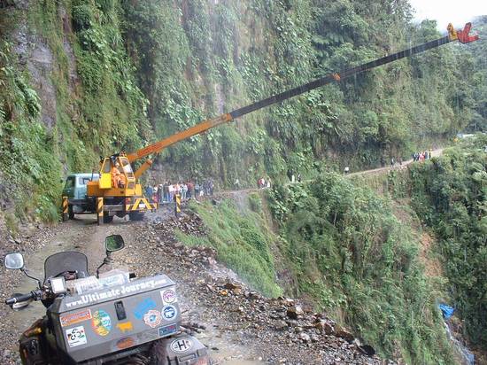
The road was blocked because a crane had been brought in to hoist up the remaining
contents of the truck. We managed to squeeze past the traffic up to where the crane was
and take a peek over the edge. The scene was amazing, the truck looked like a bunch of
broken matchsticks at the bottom of the ravine. When we finally got under way again we
were all riding a lot more solemnly with the image of the truck in our minds. The rest of
the way was uneventful but we did not stop to take any more pictures. We were glad to be
heading back to terra firma. By 3pm we were back in La Paz. Here we split off from Kfir as
he was taking a different route to Peru. Liam, Chris and I headed for the historical
village of Tiwanaku for the winter solstice party.
 The World's
Most Dangerous Road
The World's
Most Dangerous Road