TOP
NORTH - Begin the journey west
-- Story by Erin --
After we left Atherton on
November 12th, we made progress into the real outback of Australia. Our first
stop on the northern coast was Karumba on the Gulf of Carpenteria, 670kms west of
Atherton. This is a sleepy little fishing town with a really good westerly view for
sunsets. If you don’t fish there isn’t much else to do there but admire the
sunsets. The morning after we arrived in Karumba we were rained on-----lots of it!
November is the start of what the locals call the "Build-Up", characterized by
steamy hot days and big thunderstorms. This was to be the norm for us as we crossed the
north to Katherine. We sat out the rain showers under a flimsy picnic shelter with 6 other
young Aussie fisherman. While we played cards, they enjoyed their first VB (Victoria
Bitter beer) of the day at 9:00 a.m. At about 11:00 a.m. the showers stopped and we found
that our tent was flooded. The ground under and around our tent was so saturated that the
floor of our tent just couldn’t keep out the water. We searched around town for a
cheap room to hang up our wet belongings and ended up staying in one of the overpriced
cabins in the caravan park.
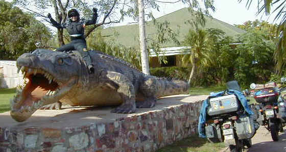
On November 14th
we left Karumba. On the way we stopped in the first town out of Karumba, Normanton. Here
rests the replica of the largest Crocodile ever caught. I don’t remember exactly how
big it is but the picture below showing me riding on top of it and my bike near by should
give you some perspective! This salt-water crocodile (called a "salty" by the
locals) was found on the banks of the Normanton River just out of town. Yikes!
Our next
stopover was Mount Isa, about 700km southwest of Karumba. Mount Isa is a sizable mining
town with a big lead smelter that dominates the horizon. We spent an extra day here to
poke around town (they have a K-Mart!) and check out the Riversleigh Fossil Center. Just
north of here in the Lawn Hill National Park, containing the Riversleigh station, which is
the sight of one of the most abundant fossil finds in the world. Scientists will be
researching this area for many more years to come.
A note should be made here
about the condition of roads in the Far North Queensland area. The main roads that connect
the major towns are mostly single-lane (not one lane in each direction) with soft
shoulders. They are also not all weather. By this I mean that they are not raised and do
flood often. Before we arrived in Australia we had heard stories of what is called a
"road-train", basically a truck pulling 3-5 trailers. Well, in this region we
had to share the single-lane road with these behemoths. These road-trains are usually
pulling 3 trailers (50 meters long!) and run at a consistent 100 km/hour. They do not pull
off to the shoulder to let you pass, and you wouldn’t want them to. If they pull off
the road at those speeds they risk losing control and crashing. At the very least they
will throw up so much dirt and rocks that you would be dusting yourself off for days and
looking for a new windshield. The only alternative is to pull off and stop on the shoulder
of the road and hang on tight until they pass. If it has rained recently the shoulder can
be like quick sand and get you bogged. The truck drivers appreciate this gesture and will
always give you a wave and a smile as they pass.
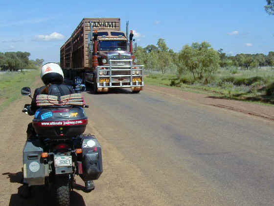
Make way for the Road Train -- This is 3 trailers, each trailer
is stacked with 2 layers of cattle.
|
These
road-trains do a lot of damage to the local wildlife. Poor kangaroos, wild boars, cattle,
eagles, rabbits, goannas and various other animals don’t stand a chance when a
road-train bears down on them. You can see the carnage on every major road in the north of
Australia. This does nothing for population control however, as the government authorizes
controlled killings of various groups of animals each year, including wild horses,
kangaroos, camels, donkey’s and boars.
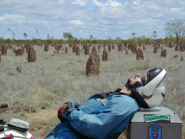
Chris taking a rest among the Termite mounds -- A typical site in
the outback.
|
We left
Mount Isa on November 17th, crossed the border into the Northern Territory and
arrived in Tennant Creek (population 3,500) some 635 kilometers away. When we crossed the
border into the NT the roads immediately got better. We were treated to wide two-lane
roads with paved shoulders and painted line markings. (These are the things you focus on
when there isn’t much else to see in the monotoned/monochrome feeling of the
outback.) In TC we met Graham and Pauline Buxton who we had been writing to by email since
before we arrived in Australia. Graham and Pauline are both transplanted Poms (an
affectionate Aussie nickname for the Brits) in the healthcare field and Graham works with
the local public health organization working with the area's population of Aborigines. He
and Pauline gave us the grand tour of the Tennant Creek area, which is rich in Aborigine
history and culture. Geographically, TC is the center of the northern part of Australia
and was also a big gold mining area in the early 1900’s. We took a tour of an
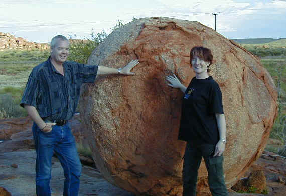
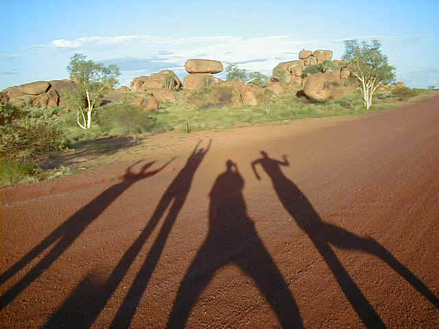
underground gold mine, visited the important Aboriginal dreaming sights of the
Devil’s Marbles and its female equivalent, the Pebbles. The marbles are large
square boulders that, through erosion, have had their edges rounded off, giving the
appearance of large marbles.
Graham and Pauline
|
We wandered
around the old Telegraph Station, which is only one of three remaining intact in the
north. The telegraph station could send messages all the way to England via an underwater
cable through Jakarta in Indonesia. The station workers would have lived a very lonely
life out there! Our last night in TC Graham and Pauline cooked us a wonderful Indian meal,
and the next day we bid them goodbye.
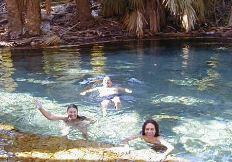
From Tennant Creek we
headed north again, November 20th, in the direction of Katherine, another
700kms to the north. About 100 kilometers south of Katherine we stopped at Mataranka
Homestead. Here there is a big thermal hot springs that we made good use of both that
afternoon and the next morning. Although the temperature was about 40C/105F the Hot
Springs was still a refreshing break! As we headed north the next day you could feel the
humidity rise considerably.
We arrived
in Katherine on the 21st and found that our friends Anke and Jan had arrived
one day ahead of us. Thankfully we had ordered new tires to be shipped to Katherine. Our
knobby rear tires had been ground down smooth due to the flat straight roads, the heat,
and the composition of the pavement, eating away at the rubber. (We expect our current
tires to last us only until we get around to Adelaide or Melbourne-----not the best
mileage!) Katherine is a decent size town (pop. 11,000) and is the gateway to the popular
northern national parks of Litchfield and Kakadu, and to the Northern Territories capital
city of Darwin. The hot, humid weather kept us from going farther north, although we did
take a day to explore and canoe the popular Katherine Gorge. In Katherine we also met
another motorbiking couple, Canadian riders Cindy and Dan from Vancouver, BC. They had
flown to Australia and bought 2 bikes in Sydney, a R100GS/PD and a Kawasaki 550, to travel
around on for 5 months. We traveled together off and on for several weeks.
Prior to departing
Katherine, we had a wonderful Thanksgiving dinner at our caravan park with Anke &
Jan. The menu included stuffed roasted chickens from the supermarket, canned potato
salad, discounted (but fresh) cheese and bacon bread rolls, cucumber salad (hand made),
and the local Aussie favorite for desert: Lemingtons -- soft vanilla cake, coated in
chocolate, and sprinkled with coconut shavings -- delicious!
Having fun at Devil's Marbles |
|